Old Boundaries
at Waiouru
12a. Three
Boundary Pou
The
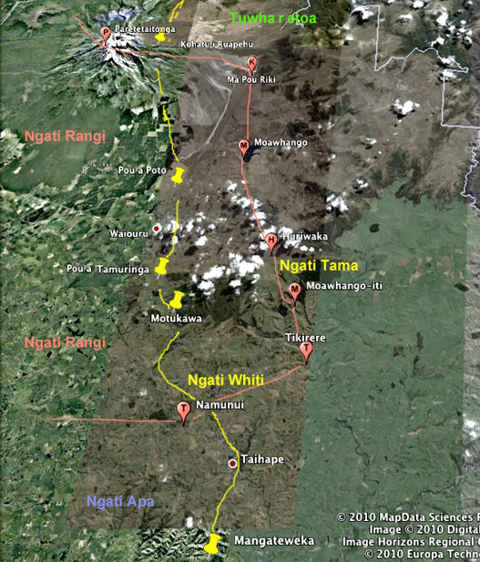
Waiouru Army Training Area falls inside overlapping
boundaries
of Whanganui and Taupo/Inland Patea
Iwi.
Researched by John Archer.
First
published in the Waiouru Tussock Times in Jan 2010.
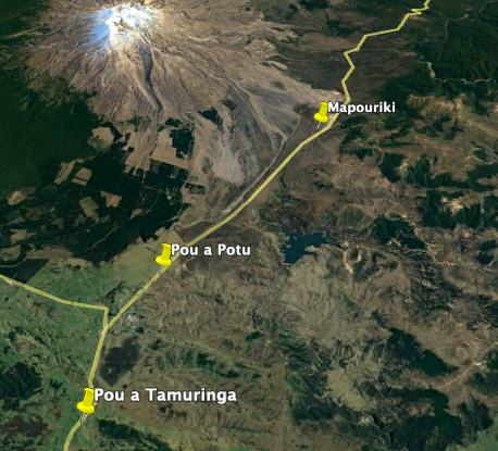
A. Ma-pou-riki, or Roro-o-Tai-ariki
In
the
1880s, “Mapouriki”
was the name Pakeha surveyors recorded as their
place to get water for their campsite at the summit of
today's Desert Road, just south of the turnoff into
Tukino skifield. 
The
Whanganui
leader Te Keepa, or Major
Kemp,
had an armed stand-off 10 km east of Waiouru in
January 1880, and then
was diddled in a land-court
hearing near Tokaanu in April 1880, so in November
1880 he placed a ban on all sales of land within the
Whanganui region.
He
erected
a carved pole ("Kemp's Pole") at the high tide mark
of the Whanganui River (between Kaiwhaiki and
Parakino), saying
"I
will
go on to tell of the boundary lines of the land
proclaimed by me on the 18th of last month, and
which I have verified and adhered to to this day.
The boundaries commence west of Wanganui, right on
to Kaitangiwhenua, (Waitotara
Valley)
thence
to
Rimupoto,
(near Taumarunui)
on to Ruapehu, to Roro-o-Taiariki,
Tikihere, (Tikirere,near
Moawhango)
to Houhou,
(near Hunterville)
Kaiwhaiki, (lower
Whanganui
River)
and on to where am now standing to Kouarapaoa.
Historians
variously say that Te Keepa went on to erect other
poles near the end of the Waitotara Valley road "at
Kai-tangata-whenua" or "at Matemateonga"), at "Te
Houhou" or "on the banks of the Rangitikei River, near
the marae at Rata" and somewhere "near Waiouru"
or "close to the Moawahango river."
"Mapouriki"
was previously known as "Te
Roro
o Taiteariki"
because this place commemorates where Taiteariki
(Tai te ariki), who was born in Tahiti in
about 1275, became an ariki in Rarotonga, and got
his brains battered out on the the Rangipo Desert at
Onetapu.
Te
Keepa calls the place "Roro-o-Taiariki," so I
presume he placed his boundary pou there. The stream
you can see there, right beside State Highway One,
is the western headwaters of the Moawhango river -
the road crosses the headwaters of the Waikato only
a kilometre to the north.
So why the name changes? Te Roro o Tai-te-ariki =>
Roro-o-Tai-ariki => Ma-pou-ariki =>
Ma-pou-riki?? Is that referring to the white area (ma)
that establishes (pou) the tribal boundary? Next time
you drive past, notice the white sand there. Or stop
and go for a walk: there is a white cushion plant in
the Onetapu Desert that looks just like a human brain.
Te roro o Tai te ariki?
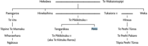
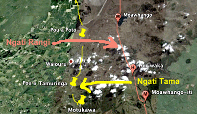
B. Pou a Poto,
or Kōmu a Poto
As
you drive up the hill past Abassia Camp, 5 km north
of Waiouru, there is another pou site, still
marked on today’s topo maps, Pou
a Poto
or Kōmu a Poto (Silent spade of Potu). It was used
by the Land Court in 1880 to divide the Murimotu
Block (awarded to Ngati Rangi,) from the Rangipo
Block (awarded to Ngati Hutu at Lake Rotoaira)
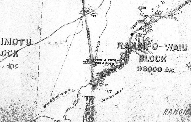
This
pou was presumably put there by Poto, the son
of Te Pikikōtuku who lived at
Manganui-o-te-ao. Poto was a cousin of the
great chief Te Peehi Turoa, who signed the
Treaty of Waitangi at Whanganui on behalf of
Ruapeu iwi, in which case he
may have thrust
a wooden spade into the hilltop there as a
boundary marker in 1850 after an inter-tribal
hui near Hihitahi to settle boundaries.
C. Te Pou a Tamuringa
As
you drive up and over Tracy Peters Hill 6 km south of
Waiouru, (200 metres south of Tracy Peters farmhouse)
just beside State Highway One is the place where "Te
Pou a Tamuringa" marked another boundary, probably
between Ngati Rangi at Karioi and Ngati Tama at
Moawhango.
A colonial surveyor found the ancient carved pou there
in 1874. And in
2010, 85-year-old Mrs Cozens, who had
been living nearby since the 1930s, t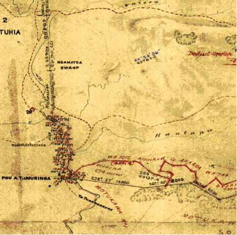 old
me that there was still a carved marker on her dad’s
boundary fence in the early 20th
century. old
me that there was still a carved marker on her dad’s
boundary fence in the early 20th
century.
Tamuringa was a great-grandson of Paerangi, founder of
Ngati PaeRangi.
Ngati Rangi did have claims to the land down the west
side of today’s State Highway One, presumably for
autumn bird-hunting, but they had stopped using it by
the early 19th
century, and in the 1840s Ngati Tama at Moawhango took
it over the valley. Then in the 1880s wool prices went
sky high and a colonist with a Ngati Rangi wife moved
back to it, building shepherds’ cottages at Hihitahi
(near Levi Vaoga’s present house). In 1884, after the
colonist and his wife refused to go away, and the
courts had refused to give Ngati Tama ownership of the
land, three Ngati Tama men burnt the houses down.
12b. Overlapping Tribal
Boundaries
 The Waiouru Army Training Area falls inside
overlapping
boundaries
of Whanganui and Taupo/Inland Patea
Iwi.
Researched by John Archer.
First published in the Waiouru Tussock
Times in Jan 2010.
The Waiouru Army Training Area falls inside
overlapping
boundaries
of Whanganui and Taupo/Inland Patea
Iwi.
Researched by John Archer.
First published in the Waiouru Tussock
Times in Jan 2010.
A.
Ngati Rangi Boundaries
In
this letter to the Wanganui Herald
in June 1883, Te
Keepa was setting out more exact
boundaries of land that was not to be
sold in the Whanganui area.
I
have done my best to untangle these
boundary names. Any corrections
would be appreciated. The first
dozen names must mark the Whanganui
rohe from near Waitotara, to Tieke,
to Taumarunui, but I
can't find the names in red on any
documents from the 1880s,
or on any of today's maps. I'll try
to get copies of the maps of the
Waitotara/Upper Whanganui made in
the 1880s. I'd be delighted if you
can identify any of the places
highlighted below.
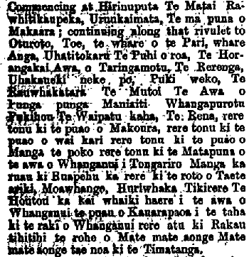
Commencing
at
Hirinuputa
Te Matai (?)
enter
into
Kaimata,
(east
of Inglewood)
The
headwaters of
Makaara(south
of Inglewood)
continuing
along
that rivulet to Oturoto,
(inland
of Patea)
Toe,
Pari's
house, (?)
Anga's
house, (?)
Whatitokaru,
(?)
Te
Puhioroa,
(?)
Te
Horangakai stream
(?)
at
Taringamotu,
(6 Km N.E. of Taumarunui)
Te
Rerenga, (Te
Rerenga-o-ko-Inaki)
Uhakaueki
neke
po,
(Whakaue
ki
neke po?)
Pukeweka,
(at
Manunui,
5 km E. of Taumarunui)
Te
Rauwhakatara
(?)
Te
Mutoi
(?)
the
river
at Pungapunga, (10
km
S.E. of Taumarunui)
Maniaiti,
(Benneydale)
Whangapurotu,
(near
Manunui)
Pukehou
(10
km east of Manunui)
Te
Waipatu
kaha,
(?)
Te
Rena,
(?)
fly
to the mouth of the Makoura
(?)
fly
on
to the mouth of the Waikarirere,
(?)
then
to
the mouth of the Mangatepopo
(river), (20 km N.E. of Tongariro)
then
to
the source of the Whanganui River on
Mount Tongariro
fly
on
to Ruapehu
fly
across
to Te
Roro
o Tai-te-ariki
(at
the
summit of the Desert Road)
Moawhango
(near
the
river bank west of the Moawhango
Hydro Lake)
Huriwaka
(near Round Bush, north of
Moawhango village)
Tikirere
(the
stream
west of Moawhango village)
Te
Houhou,
(on
the
bank of the Rangitikei River
opposite Tokorangi marae)
to
Kaiwhaiki
(10
km
north of Wanganui city)
go
up the Whanganui River to the mouth
of the Kauarapaoa
(6 km north of
Kaiwaiki)
travel
along
its side to the north of Wanganui (town)
fly
on
to the tree on the summit marking
the boundary of Matemateaonga
From
Matemateonga
(now a DoC
track) you arrive back at
the start.
B.
Tuwharetoa boundaries
Now
things
start to get tricky with those
boundaries near the Desert Road,
because the Tuwharetoa people also
claim the land between Waiouru and
Moawhango, as I
discovered in a May 1895
description of what the
Taupo/Inland Patea iwi considered
to be their boundaries:
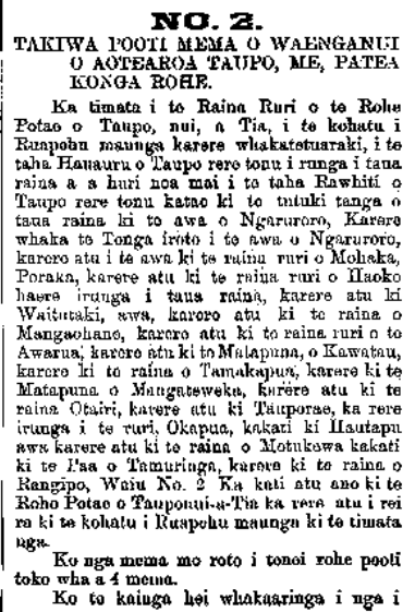
Takiwa
Pooti Mema O Waenganui O
Aotearoa Taupo Me Patea Ko
nga Rohe.
The
Boundaries
for the Elected District
Members within the
Taupo/Inland Patea
District
Te
7
O Maehe, 1895 The
7th of May 1895
Ka
timata
i Start
te
Raina Ruri the
survey
line
o
te Rohe Potae o of
the
area enclosing
Taupo-nui-a-Tia,
1.
i
te kohatu i Ruapehu Maunga
karere whaka-te-tu-araki,
at
the
“rock of Mt Ruapehu that
juts out as a pedestal for
a chief,"
(ie,
the
outcrop above Whangaehu
Gorge)
2.
i te taha hauauru o Taupo
rere tonu
keep
on
zooming to the western
side of Lake Taupo
3.
i runga i taua raina a a
huri noa mai i to taha
rawhiti o Taupo
above
that
line now turn alongside
the east of Lake Taupo
4.
rere tonu ka tae ki te
Tutuki tanga o taua raina ki
to awa o Ngaruroro,
keep
going
until you arrive where the
Tukituki River hits that
line to the Ngaro River
...?
13.
ka
rere ki te matapuna o
Mangateweka,
fly
to
the headwaters of the
Mangateweka stream.
(At
the
top of the hill on SH1
between Mangaweka and
Taihape)
14.
karere atu ki te raina Otairi
fly
away to the Otairi (survey) line
(Otairi
is a long way west of Mangaweka! We rode on
horseback from Mangamahu to Otairi 1952. This
probably refers to the Pukeroa hilltop.)
15. karere atu ki
Tauporae
fly
away to Tauporae
(this
hilltop north of Ohingaiti is halfway between
Otairi and Mangateweka. I think the Hawkes Bay
person who made this list wasn't very familiar
with this area he was claiming!)
16. ka rere i te
ruri Okapua,
fly
along the Okapua survey (line)
(due
north from Tauporae hill top to Mataroa)
17.
ka
kati ki Hautapu awa
bite
into
the Hautapu river
(the railway line follows
this river from Taihape to
Waiouru)
18.
ka
rere atu ki te raina o
Motukowa
fly
on
to the line of Motukawa
Bush reserve - 10 km south
of Waiouru
19.
ka
kati ki te Paa
o
Tamuringa,
bite
into
the Pou o Tamuringa
(at the top of Tracy
Peters' Hill on SH1, about
6 km south of Waiouru)
20.
ka
rere ki te raina o Rangipo,
Waiu No. 2
fly
to
to the line of the
Rangipo/Waiu No 2 Block.
(This
starts
6 km North of Waiouru at
the old Pou a Poto
boundary marker
It
is
called the "Pouapoto" trig
station on modern maps)
Ka
kati
atu ano ki te Roho Potae o
Tauponui-a-Tia
That
completes
the perimeter of the
greater Taupo district
ka
rere
atu i rei ra ki te kohatu i
Ruapehu maunga ki te timata
nga.
Fly
on
back to the (Whangaehu
Gorge) rock on Mt Ruapehu
to where we started)
C.
Overlapping boundaries
When
you
plot these boundary
markers onto a map, you
find the land from the
top of the Taihape
Deviation to the top of
the Desert Road,
approx-imately between
State Highway One and
the Moawhango River, is
claimed by both
Whanganui and Tuwharetoa
tribes.
Basically
Whanganui
Maori in the west of
Waiouru claimed land
as far as 15 km east
of Waiouru. But, as
seen on the map
below, the Iwi to
the north and east
of Waiouru claimed
boundaries that were
only 5 km east of
Waiouru. So there
was a strip of land
10 km wide between
the Hautapu and
Moawhango Rivers
that both parties
had laid claim to.
It's
great how much you can
find out by
continually putting
searches into Google,
eh?
Next
The
Murimotu Wool
Wars
|